RUNNING ON EMPTY
After a late start (2 pm), I pushed it 5 hours north through some of the most remote country this side of Siberia. US 93 is a desolate stretch of road connecting Arizona to Montana; this stretch through NV may be its most remote section. To the East and West are hundreds of unnamed peaks all riddled with the same strain of geological inbreeding making them all the same color and topography. I pass through towns named Calinente (which contradictory to its name was sporting a high of 65 degrees), Pioche, Pony Springs and Hogum. The mining boom of the early 1900's built these towns with drifters looking for a quick score in gold and silver. Today they are nothing but a few boards posing as homesteads overgrown with desert vegitation and clinging to the hopes that a toursist gimmick will somehow save them. As I passed through I envisioned how different my life would be if I grew-up here as opposed to suburbs of Atlanta. What if Tyler grew-up here? Would he be the one riding that tractor down main street with no shirt, no shoes and a dirt stash?
It is 336 miles to Baker, NV, home of Great Basin NP and my goal for today. I topped off the tank in Henderson, NV, meandered through Lake Mead before jumping on the 93 just outside of Moapa. When I hit Ash Springs, NV I glanced at the gas gauge and noticed that I had nearly 3/4 of a tank left. With less than 200 miles to go I took a brief detour on the Extraterrestial Highway before continuing on to Baker. By the time I hit the Hogum junction at the 93/50 I noticed that I was just a sliver above "E". I was hoping that there would be some sort of gas at this juncture since it had been nearly 100 miles since I last saw gas in Caliente. No luck.
I was now stuck with a tough decision. North on the 93 to Ely, 28 miles, or East on 50 to Baker, 35 miles. Before making any rash decisions I dropped by Stucco's Grill which was conveniently located at the junction and consulted with the bar keep on my options. Scrappy (no joke) didn't have an opinion which way he thought was best but did confirm that there was gas in Baker just pass the park entrance. So I went back to consult the map. It was nearly a 3,000 foot climb up to Sacramento Pass on Hwy 50 just before dropping 2,500 ft back down into Baker. I remember my buddy Alex Strong telling me he once coasted 30 miles through Great Smokey Mountain NP on one gallon of gas all the way to Gatlinburg. My plan was to make it to Sacramento Pass and then throw it into neutral and coast into town.
On the map the road takes a long bend before heading up hill. My hope was that the gas light would stay off until I started my uphill ascent leaving me roughly 3 gallons to make it up and over the mountain; 25 miles. Of course, as soon as I pull out of Stucco's Grill the light pops on. I immediately reconsider option # 2, Ely, but decided to stick with my gut and press on. I devised a variety of back-up plans as I drove just in case I ran out before making it to the station. These plans included stopping at one of the local farms and asking for gas, siphoning gas from a local tractor, having someone tow me up the hill, and even running off into the mountains and panning for gold and silver (I think that was the mining country getting to me). Luckily it didn't come to this.
As I drove up the mountain pass I felt like I was playing chicken with the gas needle. I put the flashers on and put the cruise control on 45 mph. The more I climbed, the closer the needle came to "E". I wish I knew how much was in the reserve tank. I thought of Kramer from Seinfeld, why couldn't he be my friend. Then I would know for certain how much gas was left in the tank.
Once I crested Sacramento Pass I took a big sigh. I popped the car in neutral and prayed that I would make it to Baker without having to walk. I then made the below video before pulling into the pump and topping off the Pilot; then praised God! Day one in the books.
PHOTO OF THE DAY
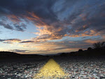
Final Sunset - Route 66 AZ
Pics from the Road

COME RIDE SHOTGUN


The Man Behind the Journey

- nationalparkman
- Traveling the country in search of new cultures, beautiful places, and a little bit more about himself.
SPONSORS OF RHODES RAGE 2009
This is my brother-in-laws company
Offical gear & clothing sponsor
Offical bike sponsor

Offical Destination Hardware Sponsor

Offical beverage sponsor
No comments:
Post a Comment